
Severe Weather Summary: Late March to Early April 2025
Over the past week or so, our team has successfully deployed Project WeatherEye across multiple severe weather events. With limited hardware at our disposal (for now), these deployments have provided valuable insights and opportunities to refine the system ahead of the peak severe weather season. Below is a summary of our recent activities and key takeaways.
March 30: Initial Deployments

March 30, 2025 SPC Risk
We kicked off the week by deploying RDD-3 twice and RDD-1 once. RDD-3 was positioned first near Thayer, Missouri, during tornado warnings, and later repositioned near Marked Tree, Arkansas, that evening. Although no tornadoes materialized, the deployments gave us critical visuals. Meanwhile, RDD-1 was stationed near Rector, Arkansas, to monitor an incoming squall line. These early tests helped us assess positioning and system performance under dynamic conditions.

RDD-3 Visual
(below) RDD-1 Timelapse from Rector, AR.
April 1: A Forecast Miss
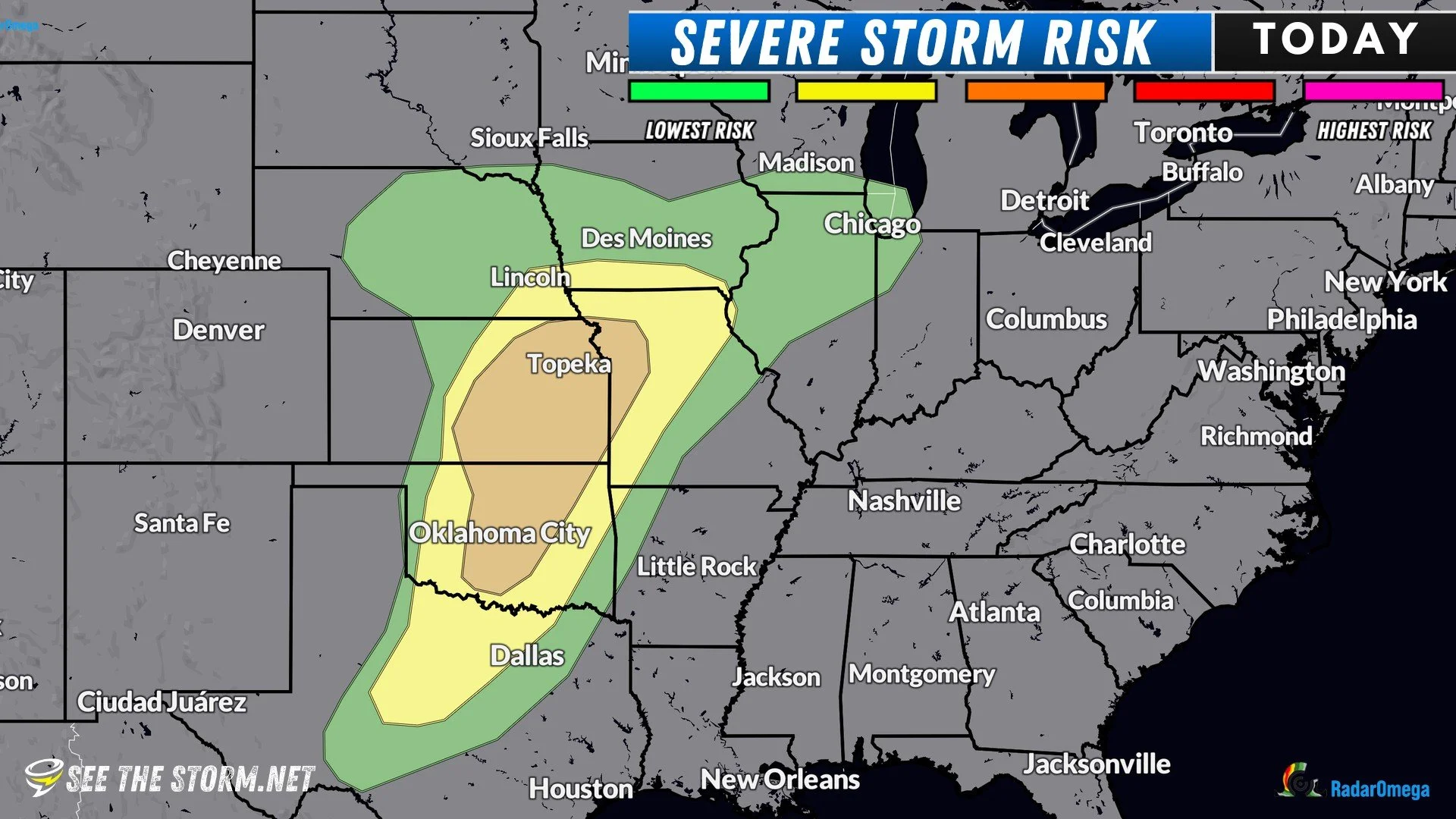
April 1, 2025 SPC Risk
Originally slated as a deployment day for WeatherEye, April 1 turned out to be a major bust in Oklahoma. Despite a Level 3/5 risk for severe storms issued by the Storm Prediction Center (SPC), the weather failed to deliver, with almost no significant activity. We opted to skip hardware deployment and instead relied on mobile live streams to track the day’s developments—or lack thereof.
April 2: High Risk

April 2, 2025 SPC Risk
April 2 brought a Level 5/5 risk across parts of the Memphis region and surrounding areas. The majority of tornado activity formed back into Arkansas, not by a line of pre-frontal storms forming in western Tennessee. Typically, we’d expect enhanced tornado potential with such pre-frontal cells, but this event underscored the unpredictable nature of severe storm forecasting—a reminder of the challenges inherent in this project. We deployed RDD-1, RDD-2, and RDD-3 to capture highly active lightning storms as they crossed the Mississippi River later that day. See one of the video clips below.
April 3: Another Underperformer

April 3, 2025 SPC Risk
Despite another Level 3/5 risk, April 3 fell flat. We deployed RDD-3 originally near Forrest City, but moved it south near Marvell, Arkansas, for a few hours to monitor the skies to the south and west, supplementing this with mobile streams to track severe thunderstorm and tornado warnings. While a line of storms did move through, it was largely uneventful, failing to live up to expectations.

RadarOmega
April 4: A Highlight of the Week

April 4, 2025 SPC Risk
April 4 proved to be our most significant day yet. The SPC issued a Level 4/5 risk with two clear targets: a northern zone around Little Rock, Arkansas, and a southern zone near Texarkana and northeast Texas. We deployed RDD-3 near New Boston, Texas, early in the afternoon to monitor incoming squalls, while keeping RDD-1 and RDD-2 ready for storm-specific deployments.

RDD-3
This strategy paid off. RDD-1 was deployed twice—first in Clarksville, Texas, during a tornado warning. That storm produced a tornado lasting a few minutes, and we captured its final moments as it approached. Had the tornado persisted longer, as we anticipated, RDD-1 likely would have taken a direct hit or come very close to it. Check out the video below, in real-time. Seek through to around the middle of the clip and you’ll see the tornado just south of town, or watch the cropped in clip.
Later, we repositioned RDD-1 to Hughes Springs, Texas, for another tornado-warned storm. While no visible tornado formed at that time, the storm’s structure was striking and well worth documenting- and nearly 600 viewers in the app thought so, too.
April 4: Part 2! Texarkana Flooding
A flash flood emergency was issued for Texarkana later in the evening, and we deployed RDD-3 to monitor a river that flooded out of its banks. This was more of a proof of concept and an investigation into how well these units work for flood coverage.
April 5: Mobile Coverage Only

April 5, 2025 Risk Map
We opted not to deploy WeatherEye equipment on April 5, focusing instead on mobile live streams. A stunning shelf cloud crossed the Mississippi River near Clarksdale, Mississippi, offering a visual treat, while several tornado warnings were issued southwest of Tupelo later that evening.
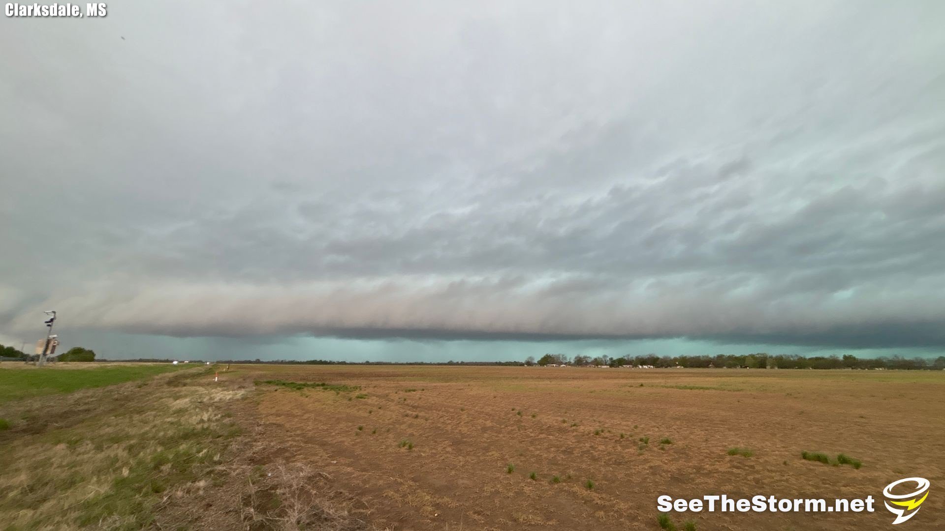
Pretty shelf cloud approaches Clarksdale, MS.

Approaching Tornado-Producing Storm near Pontotoc, Mississippi.
Lessons Learned
These deployments have been a proving ground for both our equipment and our processes. Two key improvements have emerged:
IR/Night Vision Adjustments: The camera mounts on our IR-equipped RDD units need slight trimming. Currently, infrared light reflects off the mount—just outside the camera’s field of view—causing a blinding effect. A small adjustment will resolve this issue.
Deployment Efficiency: Our webbed lash straps, while functional, are less convenient than we’d hoped. Switching to 48-inch heavy-duty zip ties will streamline setup and takedown. They’re faster to deploy, easy to cut with a wire cutter, and simple to dispose of responsibly at the next opportunity.
Looking Ahead
With severe weather season ramping up, these early deployments have been invaluable for identifying strengths and areas for improvement. We’re committed to enhancing WeatherEye’s capabilities and delivering real-time insights into nature’s most powerful storms. Stay alert for more updates as we continue this journey.